
The Costs of Smart Growth Revisited
For years the anti-sprawl, anti-automobile movement (operating under the misnomer of “smart growth”) has been pumping out reports purporting to show how more market oriented, decentralized urban development imposes inordinate costs on consumers. These reports have virtually always focused on a particular element of cost, such as public infrastructure or transportation. One of the best examples was “Driven to Spend” report by the Surface Transportation Policy Project (STPP),[1] which developed a complex sprawl classification to which it applied US Department of Labor Consumer Expenditure Survey[2] transportation data. The not surprising conclusion was that households in more sprawling metropolitan areas pay more in transportation expenditures than those living in less sprawling areas. But there is more to the cost of living than public infrastructure and transportation and to genuinely examine the costs of more or less sprawl requires examination of all costs. To conclude that sprawl is more expensive on the basis of higher public infrastructure costs or higher transportation costs is akin to concluding that a house with a more expensive air conditioner is more expensive than another with a less expensive unit. Maybe yes and maybe no. There is more to the cost of a house than the cost of the air conditioner. What is Sprawl? But before examining a more representative array of data, it is necessary to define sprawl. Despite the gallons of ink and gigabytes of broadband that have been employed to define sprawl, it is all very simple. Sprawl has to do with more land being occupied by the same number of people. An urban area of 1,000,000 population that covers 500 square miles sprawls more than one that covers 400 square miles. It is as simple as that. Or, the more densely populated an urban area, the less it sprawls. Further, virtually all so-called “smart growth” strategies require higher population densities. False Doctrine: That having been said, it is appropriate to put aside the “great Satan” doctrinal characterization of sprawl. Sprawl is neither good nor bad in itself. There is no shortage of land in the United States that justifies any great concern about sprawl --- after 400 years of settlement; only 2.6 percent of the land is urbanized, according to the 2000 census. The anti-sprawl/anti-automobile crowd often equates “livability” with urban areas that sprawl less. Yet the data is clear, both internationally and nationally, that where sprawl is greater (densities are lower), people spend less time in traffic congestion, work trips take less time, air pollution is less intense and home ownership is greater.[3] Talk about livability. The Latest Data: The 1999-2000 Consumer Expenditure data is now available. This report analyzes the new data using simple categories of sprawl, based upon the population densities of the urbanized areas within metropolitan areas of more than 1,000,000 population.[4] It further takes the STPP analysis further, to include the costs housing (including shelter, utilities and public services) and food consumed at home. Four categories of sprawl are employed (Table 1):
Transportation Expenditures: The population density categorization of sprawl does not yield the same results as the previous STPP analysis. Higher transportation expenditures are generally associated with less sprawl. The Least Sprawl areas (densities above 4,500) had annual household transportation expenditures nearly $1,300 above those of the Most Sprawl category (under 2,500 density). The Less Sprawl and More Sprawl categories exhibited transportation expenditures well below the Least Sprawl category and well above the Most Sprawl category (Table 1). The highest transportation expenditures were in San Francisco-San Jose (with one of the nation’s best transit systems), San Diego (with three new light rail lines and one new commuter rail line) and auto-oriented Houston. The lowest transportation expenditures were in Pittsburgh, Boston and Philadelphia (Table 7). The three highest expenditure metropolitan areas had an average density of 3,711, 62 percent above the 2,290 average of the three lowest expenditure areas. Housing Expenditures: Large differences were identified in housing expenditures (shelter, utilities and public services). Expenditures in the Least Sprawl category were $4,175 higher than the Most Sprawl category (Table 2). The Expenditures in the More Sprawl category were $2,331 higher, and $1,506 higher in the More Sprawl category. The highest housing expenditures were in San Francisco-San Jose, New York and Washington, while the lowest were in Pittsburgh, Tampa-St. Petersburg and St. Louis (Table 7). The three highest expenditure metropolitan areas had an average density of 4.086, 74 percent above the 2,355 average for the three lowest expenditure areas. Food at Home Expenditures: As in transportation and housing, the lowest expenditures were in the Most Sprawl category. Expenditures in the Least Sprawl category were $1,276 higher than the Most Sprawl category, while the Less Sprawl and More Sprawl categories were $528 and $483 higher respectively (Table 3). The highest food at home expenditures were in San Francisco-San Jose, Dallas-Fort Worth and Seattle, while the lowest were in Tampa-St. Petersburg, Milwaukee and Atlanta (Table 7). The three highest expenditure metropolitan areas had an average density of 3,433, 46 percent above the 2,351 average for the three lowest expenditure areas. Total Expenditures: Overall expenditures on transportation, housing and food at home were by far the lowest in the Most Sprawl category, at $22,334 annually. This compares to (Table 5 and Figure 1):
The highest overall expenditures were in San Francisco-San Jose, San Diego and New York, while the lowest overall expenditures were in Pittsburgh, Tampa-St. Petersburg and Milwaukee (Table 7).[5] The three highest expenditure metropolitan areas had an average density of 4.192, 72 percent above the 2,435 average for the three lowest expenditure areas.
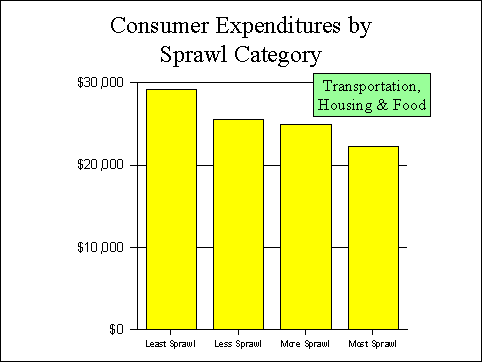 Figure 1 Home Ownership: It is not surprising that higher expenditures should be associated with lower levels of home ownership. The less sprawling, more expensive metropolitan areas tend to have significantly lower rates of home ownership than the areas that sprawl more (Table 6 and Figure 2).[6]
Los Angeles, New York and San Diego have the lowest home-ownership rates, while Philadelphia, St. Louis and Pittsburgh have the highest home ownership rates (Table 7). The three highest home-ownership metropolitan areas had an average density of 2,392, 45 percent above the 4,352 average for the three lowest home-ownership areas. Moreover, Dr. Matthew Kahn of Tufts University has published research indicating that this finding applies to African-Americans, who represent a disproportionate percentage of lower income households. Kahn found that higher rates of home-ownership were associated with more sprawling urban areas.[7] As we have noted elsewhere, the negative relationship between smart growth and home ownership would seem to suggest that the Administration compromises its potential for succeeding at increasing minority home ownership by its continuing and ill-conceived support of smart growth (principally at the Department of Housing and Urban Development, the Department of Transportation and the Environmental Protection Agency).[8] 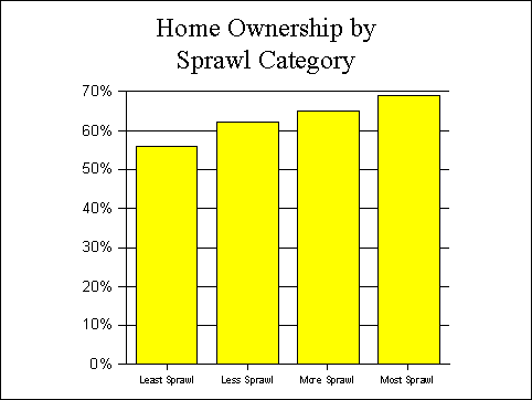
Figure 2 The Bottom Line: What all of this suggests is that the costs of smart growth are indeed high --- thousands of dollars per year per household. And the lower rates of home-ownership associated with higher density development mean that lower income households, especially minorities, face even greater hurdles as they seek entry to the economic mainstream. Moreover, much of the wealth held by the nation’s middle-income households is the result of equity in owned homes. Continued implementation of density producing smart growth policies would seem to promise a less affluent America in the future.
[2] United
States Department of Labor Bureau of Labor Statistics Consumer Expenditure
Survey (www.bls.gov). [3] Wendell Cox, Smart Growth and Housing Affordability, paper commissioned by the Millennial Housing Commission (http://www.mhc.gov/papers/coxsg.doc). [4] All 26 areas for which the Consumer Expenditure Survey reports data. [5] There is also a strong statistical relationship. A linear regression analysis with density as the independent variable and overall expenditures as the dependent variable indicates an “R” value of 0.67, well above the level required for reliability at the 99 percent significance level (0.50). Generally, each 1,000 increase in population density is associated with a $1,939 increase in overall expenditures. [6] Again, there is a strong statistical relationship. A linear regression analysis with density as the independent variable and overall expenditures as the dependent variable indicates an “R” value of 0.63, well above the level required for reliability at the 99 percent significance level (0.50). Generally, each 1,000 increase in population density is associated with a 4.5 percentage point decline in home-ownership. [7] Matthew E. Kahn, “Does Sprawl Reduce the Black/White Housing Consumption Gap?” Housing Policy Debate, Volume 12, Issue 1.
| are undertakings of WENDELL COX CONSULTANCY P. O. Box 841 - Belleville, IL 62222 USA Telephone: +1.618.632.8507 - Facsimile: +1.775.521.8564 Send E-Mail
| ||||||||||||||||||||||||||||||||||||||||||||||||||||||||||||||||||||||||||||||||||||||||||||||||||||||||||||||||||||||||||||||||||||||||||||||||||||||||||||||||||||||||||||||||||||||||||||||||||||||||||||||||||||||||||||||||||||||||||||||||||||||||||||||||||||||||||||||||||||||||||||||||||||||||||||||||||||||||||||||||||||||||||||||||||||||||||||||||||||||||||||||||||||||||||||||||||||||||||||||||||||||||||||||||||||||||||||||||||||||||||||||||||||||||||||||||||||||||||||||||||||||||||||||||||||||||||||||||||||||||||||||||||||||||||||||||||||||||||||||||||||||||||||||||||||||||||||||||||||||||||||||||||||||||||||||||

