
Portland:
Far Less Dense than Los Angeles,
Sprawling Like Phoenix
This is a part of the Demographia 1990 US Urbanized Area Density Profile product. Data may be reproduced with appropriate citation.
Data includes all census tracts of 500 or more population per square mile in the urbanized portions of the metropolitan areas
|
Los Angeles Most Dense US Urban Area: Even planning professionals are often surprised to learn that the nation's most dense urban area
is the very area perceived by many people to be the epitome of so-called "urban sprawl" --- Los Angeles. But it is true. Based upon the number
of acres consumed by urban development, no US urbanized area sprawls less than Los Angeles.
Los Angeles: Model for the World: The Los Angeles area has long been famous as a leader in suburbanization. This is because Los Angeles emerged as the world's first large very low density urban area. Two factors contributed to this.
(1) The urban area was served early by what was perhaps the world's most expansion interurban rail system. This allowed people to purchase residences far from the central area.
(2) The rate of Automobile ownership in Los Angeles led virtually all other major urban areas. While contrary to local views, Los Angeles was not the home of the first controlled access highways (they were in the New York City area), more people had cars earlier in Los Angeles than elsewhere.
By 1950, Los Angeles had become the nation's third largest urbanized area. It was also the least densely populated out of the 12 urbanized areas with more than 1,000,000 residents. At 4,589 persons per square mile, the Los Angeles area was less than one-half the density of New York and Philadelphia. The other 11 large urbanized areas had an average density of 7,075, more than 50 percent higher than Los Angeles. Even western urban areas were more dense than Los Angeles, such as Seattle, Sacramento and Denver. Portland's density was almost exactly the same as Los Angeles, at 4,500.
But in the intervening years, Los Angeles, which had led the nation in low density development to 1950, emerged as the nation's highest density urbanized area. In 1990, the Los Angeles area reached 5,800 per square mile, ahed of second ranking Miami (5,425) and New York (5,407).
Portland: Outsprawling Los Angeles: At the same time, over the past twenty years, Portland has adopted so-called "smart growth' policies, including an urban growth boundary inside which virtually all urban growth is to occur. Planning and popular literature has been filled with salivating reviews of Portland's success. But, during the 1980s, after adoption of the urban growth boundary, Portland's density of new development trailed that of all major western urbanized areas except Seattle. Further, Portland is a very low density urban area, both in its central city and its suburbs. By 1990, the Portland urbanized area was 3,021 persons per square mile, barely one-half that of Los Angeles.
Los Angeles Considerably More Dense than Portland: Overall and in Corridors: Some planners believe that Los Angeles has more
uniform densities and does not have the high corridor densities and pockets of density of other urban areas. An example is Parsons Brinckerhoff
planner G. B. Arrington, a former transit planner in Portland, who has written:
Portland has focused density in centers and corridors served by transit. Los Angeles density is more uniform, not concentrated.
As with much of the mythology that passes for conventional wisdom, a review of the facts reveals otherwise (1990 data unless otherwise noted).
- The most dense census tract in the Los Angeles area had a population density of 79,725, 3.5 times that of Portland's most dense tract, at 22,858. Data
just published in the 2000 US Census shows that the gap has widened. The most dense 1990 census tract in Los Angeles has become even more dense, at
94,450 per square mile (bounded by Vermont Ave., Normandie Ave, 3rd St and 5th St.). At the same time, Portland's most dense tract dropped to 22,683 (NE 23rd area).
- The most dense one percent of the Los Angeles urbanized area had a density of 33,900, 3.0 times Portland's 11,384.
- The most dense 10 percent of the Los Angeles urbanized area had a density of 18,118, 2.5 times Portland's 7,322.
- Further down the density scale, Los Angeles and Portland converge in density, with Los Angeles being 1.1 times as dense in the 91st to 100th
land area percentile.
- The standard deviation (a higher value means less uniformity) of census tract densities in Los Angeles (9,117) is more than three times that of Portland (2,851)
- Approximately 925,000 people in Los Angeles live in census tracts that are more dense than the densest in Portland. By comparison, the entire urbanized
area of Portland located in Oregon (part is in Washington) had only 1,005,000 residents in 1990.
- In only one regard is the density of Los Angeles more uniform than that of Portland --- Los Angeles is uniformly more dense than Portland.
Los Angeles: Largest Expanse of Over 10,000 Density: In fact, Los Angeles has the second most dense core of any metropolitan area in the developed "new world (US, Canada, Australia and New Zealand). Central Los Angeles is more dense than central Toronto, but less dense than the core of New York. But, again surprisingly, Los Angeles has the largest area of above 10,000 per square mile density in the new world, larger even than New York.
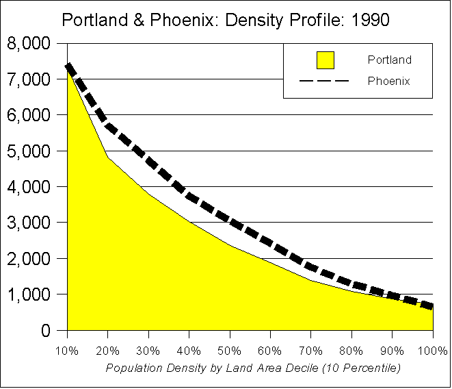
Portland Sprawls Like Phoenix: And Portland? Not only is Portland considerably less dense than Los Angeles, but its density gradient trails below more than 2/3 of the 33 urbanized areas that had a population of more than 1,000,000 in 1990 (ranking 25th in 10 percentile density). In fact, Portland's density profile is strikingly similar to that of Phoenix, known for its sprawling low density. Phoenix ranks 24th, one position above Portland (Table 2 & Figure).
The top 10 percentiles of urbanized Phoenix land area are more dense than the corresponding area of Portland.
Table 1
Los Angeles and Portland Density Profiles
|
|
Percentage of Land Area |
Los Angeles |
Portland |
Los Angeles Compared to Portland |
|
Most Dense Census Tract |
79,725 |
22,858 |
3.5 |
|
Most Dense 1% |
34,204 |
11,384 |
3.0 |
|
Most Dense 10% |
18,415 |
7,322 |
2.5 |
|
10% to 20% |
10,600 |
4,827 |
2.2 |
|
20% to 30% |
8,340 |
3,795 |
2.2 |
|
30% to 40% |
6,770 |
3,031 |
2.2 |
|
40% to 50% |
5,268 |
2,363 |
2.2 |
|
50% to 60% |
3,900 |
1,873 |
2.1 |
|
60% to 70% |
2,856 |
1,394 |
2.0 |
|
70% to 80% |
2,035 |
1,076 |
1.9 |
|
80% to 90% |
1,362 |
863 |
1.6 |
|
90% to 100% |
812 |
716 |
1.1 |
|
Data includes all census tracts of 500 or more population per square mile in the urbanized portions of Los Angeles (Los Angeles and Orange counties)
and Portland (Clackamas, Clark, Columbia, Multnomah and Washington and Yamhill counties) |
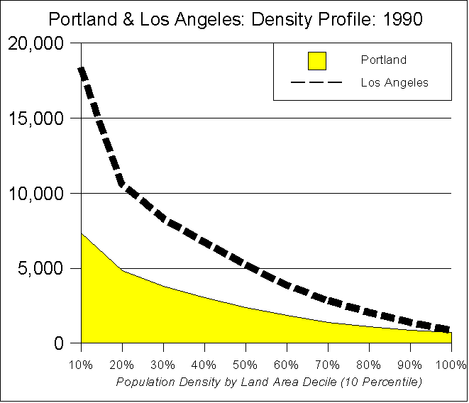
Table 2
Urbanized Areas with More than 1,000,000 Population in 1990:
Ranked by Density of Highest Density 10 Percent of Land Area
|
|
Rank |
Urbanized Area |
High Tract |
1% |
10% |
20% |
30% |
40% |
50% |
60% |
70% |
80% |
90% |
100% |
Overall |
|
1 |
New York |
227,167 |
93,782 |
29,464 |
7,088 |
4,400 |
3,184 |
2,337 |
1,734 |
1,303 |
997 |
746 |
555 |
5,184 |
|
2 |
Los Angeles |
79,725 |
34,204 |
18,415 |
10,600 |
8,340 |
6,770 |
5,268 |
3,900 |
2,856 |
2,035 |
1,362 |
812 |
6,062 |
|
3 |
San Francisco-Oakland |
145,050 |
37,948 |
17,200 |
7,900 |
5,487 |
3,847 |
2,667 |
1,972 |
1,506 |
1,090 |
753 |
570 |
4,311 |
|
4 |
Chicago |
90,550 |
34,414 |
15,035 |
5,806 |
4,030 |
2,896 |
2,138 |
1,614 |
1,290 |
1,018 |
759 |
610 |
3,525 |
|
5 |
Philadelphia |
47,731 |
33,228 |
14,814 |
5,188 |
3,360 |
2,424 |
1,910 |
1,478 |
1,165 |
913 |
694 |
570 |
3,263 |
|
6 |
Miami |
32,007 |
25,483 |
13,460 |
8,419 |
6,863 |
5,434 |
4,376 |
3,075 |
2,273 |
1,926 |
1,328 |
647 |
4,815 |
|
7 |
Boston |
86,725 |
29,973 |
12,329 |
4,404 |
2,742 |
1,874 |
1,401 |
1,087 |
848 |
729 |
632 |
548 |
2,673 |
|
8 |
San Jose |
29,246 |
17,468 |
12,251 |
8,322 |
6,944 |
5,749 |
4,133 |
2,447 |
1,454 |
1,158 |
839 |
599 |
4,401 |
|
9 |
Milwaukee |
29,173 |
20,710 |
11,432 |
5,286 |
3,214 |
2,447 |
1,744 |
1,332 |
1,024 |
933 |
797 |
568 |
2,892 |
|
10 |
Baltimore |
181,533 |
27,406 |
11,398 |
4,645 |
3,142 |
2,270 |
1,582 |
1,274 |
971 |
767 |
657 |
562 |
2,734 |
|
11 |
San Diego |
27,387 |
19,546 |
11,282 |
6,558 |
4,737 |
3,484 |
2,848 |
2,112 |
1,538 |
1,092 |
821 |
557 |
3,520 |
|
12 |
New Orleans |
41,600 |
20,415 |
11,042 |
7,035 |
5,577 |
3,569 |
2,178 |
1,464 |
1,101 |
808 |
686 |
607 |
3,441 |
|
13 |
Washington |
59,625 |
25,635 |
10,741 |
5,178 |
3,797 |
2,983 |
2,382 |
1,818 |
1,340 |
964 |
716 |
569 |
3,055 |
|
14 |
Cleveland |
26,345 |
15,517 |
9,441 |
4,987 |
3,367 |
2,522 |
1,841 |
1,310 |
986 |
816 |
663 |
540 |
2,659 |
|
15 |
Detroit |
16,737 |
13,284 |
9,259 |
6,133 |
4,547 |
3,343 |
2,586 |
1,987 |
1,529 |
1,168 |
881 |
566 |
3,204 |
|
16 |
Sacramento |
12,956 |
11,283 |
8,220 |
6,248 |
5,421 |
4,606 |
3,926 |
3,222 |
2,296 |
1,591 |
1,019 |
680 |
3,751 |
|
17 |
Pittsburgh |
40,800 |
14,893 |
7,871 |
4,084 |
2,723 |
1,805 |
1,255 |
1,023 |
776 |
667 |
591 |
532 |
2,139 |
|
18 |
Columbus |
25,922 |
14,858 |
8,000 |
4,667 |
3,674 |
2,916 |
2,076 |
1,563 |
1,204 |
919 |
735 |
595 |
2,640 |
|
19 |
Seattle |
36,900 |
14,865 |
7,837 |
5,008 |
3,964 |
3,245 |
2,554 |
2,048 |
1,582 |
1,097 |
769 |
572 |
2,876 |
|
20 |
Fort Lauderdale |
25,910 |
10,788 |
7,813 |
5,764 |
4,725 |
4,058 |
3,478 |
2,686 |
1,601 |
1,281 |
1,245 |
742 |
3,351 |
|
21 |
Denver |
22,070 |
12,321 |
7,587 |
5,553 |
4,742 |
3,903 |
3,209 |
2,528 |
1,848 |
1,321 |
885 |
592 |
3,228 |
|
22 |
Minneapolis-St. Paul |
20,643 |
13,693 |
7,458 |
4,246 |
3,193 |
2,488 |
2,021 |
1,601 |
1,254 |
961 |
685 |
536 |
2,453 |
|
23 |
Cincinnati |
44,400 |
13,487 |
7,423 |
4,069 |
2,924 |
2,134 |
1,663 |
1,309 |
1,028 |
799 |
682 |
555 |
2,270 |
|
24 |
Phoenix |
13,787 |
9,791 |
7,414 |
5,723 |
4,742 |
3,753 |
3,073 |
2,429 |
1,776 |
1,297 |
968 |
640 |
3,193 |
|
25 |
Portland |
22,858 |
11,384 |
7,322 |
4,827 |
3,795 |
3,031 |
2,363 |
1,873 |
1,394 |
1,076 |
863 |
716 |
2,738 |
|
26 |
St. Louis |
35,800 |
12,561 |
7,155 |
4,032 |
3,055 |
2,293 |
1,673 |
1,225 |
1,006 |
828 |
645 |
569 |
2,259 |
|
27 |
Houston |
14,954 |
10,726 |
6,965 |
4,618 |
3,430 |
2,696 |
2,111 |
1,694 |
1,365 |
1,098 |
820 |
595 |
2,547 |
|
28 |
San Antonio |
10,073 |
9,372 |
6,916 |
4,862 |
3,860 |
3,074 |
2,444 |
1,940 |
1,600 |
1,188 |
917 |
715 |
2,769 |
|
29 |
Dallas-Fort Worth |
17,833 |
10,855 |
6,509 |
4,341 |
3,385 |
2,621 |
2,042 |
1,463 |
1,024 |
809 |
643 |
550 |
2,346 |
|
30 |
Riverside-San Bernardino |
11,014 |
9,185 |
6,250 |
3,810 |
2,497 |
1,748 |
1,353 |
1,104 |
914 |
731 |
595 |
540 |
1,976 |
|
31 |
Tampa-St. Petersburg |
14,982 |
8,087 |
5,669 |
4,279 |
3,587 |
2,926 |
2,361 |
1,799 |
1,271 |
950 |
702 |
521 |
2,416 |
|
32 |
Kansas City |
14,295 |
9,124 |
5,638 |
3,673 |
3,000 |
2,465 |
1,904 |
1,451 |
1,156 |
828 |
648 |
537 |
2,130 |
|
33 |
Atlanta |
30,300 |
6,910 |
4,149 |
2,615 |
2,083 |
1,748 |
1,382 |
1,155 |
914 |
681 |
580 |
531 |
1,590 |
|
|
Average |
46,548 |
19,794 |
10,114 |
5,454 |
4,101 |
3,161 |
2,433 |
1,840 |
1,370 |
1,047 |
798 |
594 |
3,103 |
Data includes all census tracts of 500 or more population per square mile in the urbanized portions of Los Angeles (Los Angeles and Orange counties) and Portland (Clackamas, Clark, Multnomah and Washington counties)
Note: This analysis produces results similar to, but not identical to data for urbanized areas. |
(c) 2001 www.demographia.com --- Wendell Cox Consultancy --- Permission granted to use with attribution.
Demographia is "pro-choice" with respect to urban development.
People should have the freedom to live and work
where and how they like.
|
DEMOGRAPHIA
is an undertaking of
WENDELL COX CONSULTANCY
P. O. Box 841 - Belleville, IL 62222 USA
Telephone: +1.618.632.8507 -
Facsimile: +1.810.821.8134
E-Mail:
enquiries@demographia.com
Demographic Briefs |
New Items |
Book Store |
Subscribe (Free)
Corrections Policy, Rights & Permissions
Related Web Site:

THE PUBLIC PURPOSE
Internet Public Policy Resource
|
|